Yellowstone wildlife photos . . .
Leave a reply
We got our first idea of the Yellowstone wildlife to expect back in Cody, WY at the amazing Buffalo Bill Center of the West. In the Draper National History section there were detailed explanations of the various landscapes that make up the Greater Yellowstone region – the more open Northern Range, the lodgepole pine forests (they cover 80% of the parkland), the plains (“where the buffalo roam”) and the mountain meadows. It was just the primer we needed before heading into the park.

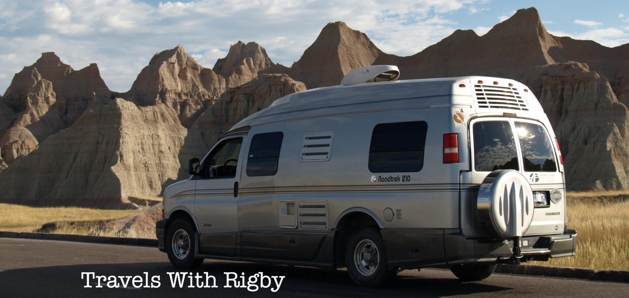
Signing into the Yellowstone campgrounds involves more than just site assignment. We had to initial a waiver acknowledging that we were in grizzly country. Huge metal food lockers for tenters to use. Lots of bear information – the what-to-do-if scenarios. Dogs are not allowed on the hiking trails (sorry Rigby) although it’s pretty easy to understand.

Now that we’re here, we’ve seen lots of wildlife (although not the elusive gray wolf nor the grizzly). So many bison that after a day or two you start to get blasé about the experience. Ditto for the elk – although we did have a magical early morning viewing of elk silhouetted against the sunrise that will be forever imprinted on our brains. There have been many deer and a coyote snoozing in the field between the geysers. One, lonely bighorn sheep (“the master of the mountain”) nibbling on some grass and a flock of snow white pelicans fishing in the Yellowstone River. At the museum we learned that the bighorn sheep have air filled chambers in their skulls to absorb head-on-blows.
On the second day in Yellowstone, we set our alarm for 6am and were on the road 15 minutes later – freshly-brewed coffee in hand – for a day devoted to wildlife watching (gotta love the Roadtrek – it really is up-and-out in no time). Luckily, the day we chose was the one day we’ve had here with clear blue skies from start to finish.
We were barely out of the campground when we came across the harem of elk, with the sun just barely coming up behind the Absaroka Mountain Range to the east. We stopped and just watched for a good 10 minutes. What a way to start the morning!
Our goal for the day were the wildlife rich Hayden and Lamar Valleys – more open grasslands favoured by the larger animals, like the bison. And we wanted to get there early, before the car traffic started to clog the roadways.
It wasn’t long before we were slowed to a crawl by our first bison jam. These iconic symbols of the West can weight 2,000 lbs and charge at 30 mph (you and me can run – maybe – 10 mph, so you do the math). If they decide to cross the road, there’s no argument.

In the early 1800s there were an estimated 60 million bison roaming the Great Plains of the West. They were hunted so intensely that they were almost wiped out – by 1890 there were fewer than a thousand left. The Yellowstone herd was protected in the early 1900s and has now grown to a herd of about 4,000.
The Lamar Valley and the Northern Range are much more open, fewer trees, more grasslands and high plateaus peppered with sagebrush. This open topography is favoured by the bison and by the grizzlies. Saw the former (in spades), still looking for the latter. Black bears prefer the mix of woods and meadows.
When you come to Yellowstone and are looking for wildlife, here’s where you want to go:
We’ve posted a separate photos-only piece about Yellowstone wildlife. Have a look. Have you been to Yellowstone? If so, what wildlife did you come across?

Think of Yellowstone as an “Acts of God Theme Park.” It’s the most apt description we could conjure. There is so much to see and do in this mammoth national park that we’ve decided to write several posts – one on the geothermal activity in the park and another on the incredible wildlife. In addition, we’re going to create a few “photos-only posts.”
A bit of background: Yellowstone is the first U.S. National Park, established in 1872 by President Ulysses S. Grant. Pull out your map – you’ll find it in the northwest corner of Wyoming (although margins of the park cross over into Montana and Idaho).
Of course, as soon as we arrived at our campground, the temperature plummeted and it snowed. We felt so sorry for the campers in tents but we stayed dry and warm. We stayed at both Grant and Madison campgrounds operated by Xanterra – if you visit, make reservations early as the campgrounds fill up (even in snowy and cold weather!). The sites were well wooded and – this was a first for us – on registration we had to sign an acknowledgement about bear activity, both black and grizzly. There are large metal food storage boxes for tenters to use and all sorts of signs about bear activity.
So, let’s start with the geothermal sights. Everyone knows about Old Faithful – it’s one of 10,000 geothermal volcanic vents in the park – it was great but not the most interesting by far. A park staff member told us it gets the most press because “you don’t have to walk far from the parking lot to get to it.”

We couldn’t get enough of the other sites – we laced up our hikers and walked the boardwalks, paths and overlooks to see steaming hot springs, mud pots belching blobs of liquid clay, geysers that erupted columns of superheated water, green, yellow and blue hot pools. And everywhere, streams of steam rising into the air.
The park is actually the location of a huge collapsed volcano caldera, the remains of the last major eruption 640,000 years ago. The huge crater marks the volcanic heart of the park. Oh yeah . . . It’s due to blow anytime and the eruption would wipe out most of the Northern hemisphere – isn’t that a cheery thought?
A few facts to wrap your mind around:

Here’s our list of the best of the best – geothermal features that really captured our attention:
www.YellowstoneNationalParkLodges.com provides info and online reservations for lodging and campgrounds in Yellowstone
There were a couple of typical small Western towns we wanted to explore on the way to Yellowstone National Park – Sheridan and Cody, both in Wyoming.

We stayed a couple of nights in the super tidy Peter D’s RV Park: walking distance from downtown Sheridan, very clean showers and laundry, Wi-Fi included (although the signal was slow when the park filled up in the evening) and very, very dog friendly. Pete met us with a couple of dog treats for Rigby and then showed us the four-acre, fenced off-leash dog yard. This was great – after being cooped up in the van with us, Rigby really needed to stretch her paws.
What we liked most about downtown Sheridan is the authentic Western town feel. No fancy airs, a beautifully restored, historic downtown main street, small independent shops and all set against a backdrop of the stunning Bighorn Mountains.
This region is the setting of the Longmire book and TV series (Netflix) – author Craig Johnson is a local fellow who writes in details about the landscape and the people here.
Sheridan has long been a railway town – the tracks run a few blocks above main street – it was a nice stop to take a break and get settled into the Western mindset. Here were the highlights of our stay:


Once we tore ourselves away from Sheridan, we went west along Highway 14 into the Bighorn National Forest and up and over the Bighorn Range on the Wyoming Scenic Byway. There was a dusting of snow on the trees at the 8,300-ft pass and we slowed down for a herd of cattle and wranglers making their way along the roadway. Outside temperature up top was just above zero Celsius. Back in Ontario they were sweating through an unusual September heatwave!


What an amazing drive! One scenic vista after another and barely passed another vehicle the whole way (cattle yes, cars not so much). After the mountains and at the edge of the Bighorn Basin we passed through Shell: population 83 and home of two establishments, a campground and the Shell Beer-Café (guess they have to cover all the bases).
We arrived in Cody and were immediately taken with the main street – again, great, authentic architecture. Cody has a beautiful location, a rodeo grounds and lots to explore in town. We only had time to spend a few hours at the world-class Buffalo Bill Center of the West (a Smithsonian affiliate museum). It is huge – divided into five smaller museum galleries from natural history to the Plains Indians to firearms.
The museum aims to immerse visitors into the story of the real American West. William F. “Buffalo Bill” Cody believed that by encountering authentic western things, people would come to understand and appreciate the West. He started as a scout for the U.S. Army but is best known for his Buffalo Bill Wild West Shows. Lots of archives on display like a cancelled Wells Fargo envelope, Pony Express saddles, telegraph equipment, etc.


The part we liked the best was the natural history (the Draper Natural History Museum) on the sights, smells and sounds of the Greater Yellowstone region. It was very hands-on and touched all the senses. Howling wolves, bubbling hot springs, raging forest fires. Could have spent a whole day just in this section.

It was a 90-minute drive to the east gates of Yellowstone National Park and another hour from there to our first night’s campground. So, more of Cody will have to be on the “next time” list. The drive east out of town is stunning – the beautiful drive up and over the Absaroca Range (a part of the Central Rocky Mountain Chain). We passed beautiful riverside campgrounds that are on our list for another time. We could happily be based in Cody for a few days to explore the town and the hiking/driving opportunities in the nearby mountains.
On to Yellowstone . . .
We travelled further west along I-90 into the South Dakota Black Hills, an area best known for wildlife and Mt. Rushmore (did the obligatory stop; it’s striking, but it didn’t hold our attention for long). The Black Hills tend to get overshadowed by the “wow” factor of the dramatic Badlands but we found it just as beautiful and just as wild, in its own way.
We camped (at the lovely Stockdale South Campground) and explored the Black Hills’ Custer State Park, South Dakota’s first state park and a don’t-miss stop. If you go this way, head into the excellent Visitor Center for information and a breathtaking widescreen movie about the region (got lots of background that helped us map out the next few days). Kevin Costner narrates, which doesn’t hurt things either!

Over the following days, we drove all the major scenic roads (which is, like, every single roadway): Iron Mountain Road with its pig-tail bridges (held up en route by a bison jam), Wildlife Loop Road, the drive to Wind Cave National Park and the nail-biting, hand-wringing, seat-clutching twists and turns of the narrow Needles Highway to the north. The latter involved three low and narrow tunnels cut into the rock that had us pulling out a tape measure first. Not kidding.
The Lakota called this land the “hills of black,” hence the name. There is a beautiful, pleasing roll to the land; the hills are covered with dark green ponderosa pine, the air is sweet with its fragrance and around every turn you’re likely to see deer, prairie dogs, elk, prairie dogs, pronghorn antelope, bison and maybe even . . . prairie dogs.
Custer State Park protects the American prairie bison. In the early 1800s, there were an estimated 30 to 60 million of the massive creatures. By the 1890s they’d been hunted down to near extinction – fewer than 1,000. Now, protected, there are 400 bison born at the park every year. The numbers are climbing and the main herd struts down the roadways like they own the place. Rigby was very interested.


Further to the south, Wind Cave National Park is “one of the biggest pieces of Swiss cheese you’ll see.” The park protects the underground cave environment known as one of the few places in the world where there are large rock formations of boxwork. To the Lakota, Wind Cave is a sacred spot – the place marking the emergence of their people into the world above.
People kept telling us not to miss the Needles Highway. This would be immediately followed by clucking about how low and narrow the rock tunnels are. This was followed by the tape measure. In the end, we decided “nothing ventured, nothing gained” and it turned out that we made it through with no problems.
It is a spectacular drive. Twists and turns, lots of lookouts and drop-offs. Beautiful views of the Black Hills and towering granite spires that give the roadway its name. We stopped and did a hike along the Cathedral Spires Trail. Most of the way in the weather started to turn (that happens incredibly quickly here) and we cut it short and went back to the van. Getting caught in the mountains in fog and rain . . . not such a good thing.
But those Black Hills – they are high on our list of places to visit again and again.
Summer is a crazy time for us both – Craig is gigging and we both have all sorts of writing assignments on the go. This translates into very few available days for our camper van travels. We always try to head out for several long (6-8 week) trips in the delicious fall and spring “shoulder seasons” when campsites are only half-filled and the weather still tempts. Shoulder season works the best for our lifestyle.

Read below for two parts: 1. Our Vermont camping trip and 2. What we learned about Class B travel this time around.
1. VERMONT IN THE SUMMER
We’ve been itching to do a trial run in our newly acquired 2006 Roadtrek 210 (we are carrying over the van’s nickname – High Cotton), so we blocked off four summertime days and crossed the border into Vermont. We have a long trip coming up in the fall – exploring U.S. national parks in South Dakota, Wyoming, Utah and Colorado – and really needed to get acquainted with the workings of the “new” van before departing on the Big Trip. 2016 is the centenary of the U.S. National Park System.
The Vermont state parks are lovely – no hookups, so the big rigs stay away and the campgrounds are small, nicely wooded with nightly rates that are very affordable (even with the dollar exchange). It’s Class B heaven.
We hopped around the state, starting with our all-time Vermont favourite, Silver Lake State Park in the hamlet of Barnard, just north of beautiful Woodstock, VT. Silver Lake is compact, the swimming in the small lake is perfect, it’s a 10-minute stroll to the quintessential VT country store in Barnard, a five-minute drive to the trailheads of the Appalachian Trail, and just 15 minutes into Woodstock, home to beautiful New England architecture, the Marsh-Billings-Rockefeller National Historic Site and the time capsule at the Billings Farm & Museum.

From there we travelled east, stopping at the Cabot Cheese outlet – loved the Alpine Cheese and the Special Reserve. Then north to Stillwater State Park, which was nice but a lot like our Ontario Parks, so we are not likely to travel there again, given that we have something very similar (and nice) just down the road from home.
Our final stay was at Grand Isle State Park, on Lake Champlain. It is one of Vermont’s largest state parks but did not seem huge or crowded. The sites were nice, clean and private. But the real find of the trip was the day-use park at Niquette Bay State Park (about 20 minutes north of Burlington, VT). What a fantastic find! It’s a one-mile hike through mature woods to the two swimming spots. We opted for Calm Cove: less crowded, slab rock shoreline, more secluded and – wait for it! …- off-leash dog friendly! Rigby had a blast jumping into the water and swimming about (as did we). There were three of four dogs there at a time – all well behaved with attentive owners. Not a single issue or problem. Niquette Bay is a bit off the beaten track, so fewer people go there, but it was the highlight of our travels.

2. THE CLASS B LEARNING CURVE CONTINUES …
Vermont has hills – small by the Rockies standard but pretty big by Ontario stats. We learned that a Roadtrek 210 is not a car; it is more like a truck so it needs to be driven like one. On the long, winding downhills, this means being judicious with the brakes (or they will overheat – very scary) and shifting to low gears to use the engine to provide some of the braking needed. The advice we received was to power down when cresting a hill to be at the speed you’d like to drive down the hill at – then use the lower gear and brakes to maintain that low speed.
All in all, we are in love with our new High Cotton. It performed flawlessly and we had fun learning the new, upgraded systems – water, dump tanks, sleeping compartment, etc. We also added an external Coleman camp stove with a combination grill/burner bought at Canadian Tire. Our van has an external propane hookup to go directly to a BBQ, so it was super easy. The camp stove is more compact and more versatile than the larger barbecues. Loved, loved, loved it. Cooked and ate outside every day. And we happened to be in Vermont just as corn season was beginning.

 Wow … that was fun!
This afternoon I got to sit in the studio and talk about my favourite Canadian destinations on The Candy Palmater Show on CBC Radio.
It was tough to whittle the list down (I could have gone on – and on – for an hour rather than the 12 minute time slot I had).
You can find the link here to the CBC spot and the audio: http://www.cbc.ca/radio/candy/the-candy-palmater-show-for-june-30-2016-1.3659588/workin-for-the-weekend-getaway-travel-writer-shares-her-favourite-canadian-destinations-1.3659697
Thanks CBC. And Happy Canada Day!
This past fall we were jonesing for a camping/RV fix – we are really missing our Class B Leisure Travel van! We travelled to the Florida Gulf Coast, rented a 25-ft Class C from Cruise America and got a taste of camping in a larger unit. The 25-ft was the smallest size in their rental fleet.

A few things we noticed:
After we returned, we published the following piece in the Toronto Star travel section:
How to have an affordable trip to the Florida Gulf Coast | Toronto Star
You can find the direct link here: http://www.thestar.com/life/travel/2016/01/15/how-to-have-an-affordable-trip-to-the-florida-gulf-coast.html
Travelling from north to south our focus was on sticking as close to the coastline as possible and experiencing everything that is unique about where salt water meets land – from shrimp boats to lighthouses to incredible stretches of wild beach.
Once we hit the borderline at Georgia-Florida, we bounced back northward, but on the return trip we headed inland, looking for music destinations and regional food highlights. Boy, did we ever find a goldmine at the small city of Macon, Georgia!
There’s a word for it: SYNERGY. It’s that magic moment when – for reasons no one fully understands – the total is greater than the sum of its parts. This happens all the time, but occasionally breaks out with transformative impact. Macon is one of those places where – at a particular moment – big things happened because the stars aligned.
It brings to mind the establishment of Capricorn Records in 1969 and the recording of the first Allman Brothers Band album. Although not a commercial success at the time, the record has since come to be seen, in the words of one critic, as “the best debut album ever delivered by an American blues band, a bold, powerful, hard-edged, soulful essay in electric blues with a native Southern ambience.” More to the point, the record put Macon on the map as the preferred destination for what would come to the called Southern Rock.
Craig savoured the displays at The Big House, a lovingly curated collection of thousands of articles – instruments, clothing, hand-written lyrics, posters, tickets and rooms of furnishings. The Big House is the spiritual and actual home of the original Allman Brothers Band – the members lived and worked from here communally in the early 1970s. It is now a museum of all things ABB.


But Macon has other claims to boast too: it’s the city that birthed Little Richard and Otis Redding. This is an incredible amount of world-class talent for such a small city (population: 90,000). The locals like to joke that “it must be something in the water.”
Of Otis Redding there is much to say. He died at the peak of his considerable power, age 26, when his plane went down en route to a gig. But the 300 songs in his catalogue and the stamp he put onto R&B and soul music have long out-lived him. It’s ironic that his best-known song – (Sittin’ On) The Dock Of The Bay – is so unlike most of the other songs in his catalogue, and that he never got to perform it. The plane crash that took his life was a mere three days after he recorded the piece. It was his biggest hit and his first million seller. But you have to see a performance, perhaps from his tour of the United Kingdom, of Try A Little Tenderness so see how this man could bring an audience to frenzy.
We had the chance to sit down with Redding’s daughter, Karla Redding, who reminisced about her dad. “My favourite piece is Love Man,” she said. “Because it’s a pure description of the man he was.” Karla spoke of his commitment to family first and foremost and his obsession with ice cream (especially butter pecan). After we left the Otis Redding Foundation and Mini-Museum we went to the waterfront to see the statue of Redding.


“Little Richard,” Wayne Penniman, is authoritatively one of the founders of rock ’n’ roll. In his induction to the Rock and Roll Hall of Fame, Ringo Starr jokingly blames “Little Richard” – for whom they opened in Hamburg – for the sound and stage energy of The Beatles. No less a figure than Mick Jagger claimed that he “couldn’t believe the power of Little Richard onstage. He was amazing.” Richard’s life story exceeds anything in fiction: he veers in and out of several near encounters with death, finds Jesus, loses him, finds him again and is condemned and honoured along the way for being so far ahead of his time. At this point in time there is no Macon museum dedicated to Little Richard . . . but, who knows what’s coming soon?
We finished up our incredible Macon stay at the H&H Soul Food Restaurant. The H&H was a favourite of “starving musicians” who found friendly faces (and meals) in the original co-owners “Mama” Inez and “Mama” Louise. It’s a Macon institution, an authentic “meat & three” as these traditional Southern eateries are called. The menus offer a meat – from meatloaf to fried chicken – and a choice of three sides (mac & cheese, fried okra, sweet potatoes, collards, etc.). The Allman Brothers members ate here as did Otis Redding when he was a member of Johnny Jenkins’ Pinetoppers. The locals like to call the women who founded the H&H “the Matriarchs of Macon’s historical music scene.”
Topped it all off with a great overnight at the Lake Tobesofkee Arrowhead Campground just 15 minutes outside of town. Spotlessly clean, well maintained sites and dark, dark, dark at night.
It’s been a few years since we heard about Cumberland Island National Seashore. Really heard about it – from an outdoorsy friend who has seen her share of wild places around the world and knows about these things. She raved about it and that immediately put this National Park Service site on our must-do list. Luckily, it fit in perfectly with this trip’s theme of exploring what is unique about life along the Atlantic coastline.
Cumberland Island sits on the very southern tip of Georgia – cross the St. Mary’s River and you are into Florida. It’s the largest barrier island along the Atlantic coastline, and definitely one with the best-preserved wilderness. That’s because Congress stepped in and designated the north part of the long, narrow island as Cumberland Island Wilderness Area, with all its protections and legislations. As Park Ranger Maggie Tyler told us, “It’s supposed to be an area where man is only a visitor.”

Cumberland Island is not somewhere you just stumble onto. You’ve got to really want to go there and a visit requires some planning. For starters there is a cap of 300 people per day. Second, the way on and off the island is by passenger ferry service only. Third, there are no commercial services on island (except for bike rentals at the ferry dock) and to get around you either bike the main road (no bikes on the trails) or hike. Visitors need to take food, water and whatever else they need for their time on island.

It’s the serenity and wilderness that draw people to Cumberland Island. The beaches and sand dunes are pristine. One-third of the state’s sea turtle nesting grounds are on the beaches of Cumberland Island. The mature maritime forest of live oaks, tall saw palmettos, myrtle and holly create a thick church-like canopy. There is a long, dirt roadway called the Grand Road that runs north-south – it is protected on the National Register of Historic Places and “has not changed in centuries.” Add in the island’s saltwater marshlands – the perfect stopover for migrating birds travelling along the Atlantic Flyway – and what you have is an intact, stable barrier island environment. These days, this is a rare thing.

It may be protected from the impact of human development now, but this was not always the case. At the turn of the 19th century, wealthy families from the north came to the island to escape the harsh winters. Over time, 90 per cent of the island was purchased by the Carnegie family (whose fortune was in steel and railroads) and they built mansions that showcased the elite lifestyles of the Gilded Age. Two of these homes remain – one is in ruins and the other, Plum Orchard, is a popular tour stop for visitors who want to roam the partially-furnished rooms to see how the one per cent lived at their winter escapes.

In the mid-20th century the homes and the land were passed to the National Park Service and under its stewardship the island is returning to its natural state of wilderness.
Cumberland Island lived up to its hype. It is a place of beauty, of solitude and of purity. If this is the type of shoreline experience you are jonesing to find, you need look no further.
***
Looking to camp? It is possible to stay on the island but you must make a reservation and bring all of your supplies. The sites are beautiful but have no water, electricity and there are pit toilets. We stayed just a few miles away from the village of St. Mary’s at the lovely Crooked River State Park. The sites were well spaces and heavily wooded and there were some nice walking trails with great views over the river. It was also very dog friendly.


